WEEKE LOCAL HISTORY
Milestones
There are three milestones within the parish of Weeke. These are :-
1. Milestone Andover Road showing:-
Winchester 1
Whitchurch 11
Newbury 23
2. Milestone Stockbridge Road showing:-
Winchester 1
Stockbridge 71/4
3. Milestone Romsey Road showing:-
Winchester 1
Romsey 10
These notes are based on an essay written by Eric Jones 1991 To Winchester one mile: some notes, historical and literary, on the three milestones in Weeke.(ref 22)
Andover Road Milestone
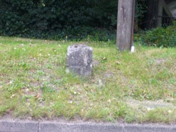
Andover Road Milestone © Barrie Brinkman
This Milestone on the Andover Road (B3420 formerly A34). This is the Roman road to Andover. Two Turnpikes use to share the last 3 miles to City. These were the Andover and Winchester Turnpike and the Winchester and Newton River Turnpike which goes to Whitchurch and Oxford.
The milepost is badly eroded, the wording Winchester 1 mile to Buttercross. Although OS map shows Whitchurch & Newbury mileages these are not on the milestone. Most of the milestone is deep into the bank alongside the road and so it is not possible to see all the wording. The Buttercross in Winchester is the point used for the mileage measurement shown on this milestone. The Buttercross was Hardys medieval cross in 1760s. It was a market point for small local produce from Hyde and Andover Road that entered the City through the Northgate.
The field behind the stone divides Barton Farm from Headbourne Worthy Down. This Barton referred to that of Hyde Abbey so was called Abbots Barton to distinguish it from Cathedrals Priors Barton at St Cross. The Abbotts Barton farm belonged to Mr Knighton who in 1761 was presented to Jane Austens father the Rectory at Steventon where she was born in 1775.
Mr Knights son inherited these lands, at Chawton and Godmersham, Kent. He married but had no children so adopted Janes elder brother Edward who then inherited these lands.
The Hyde Manor Estate was surveyed and mapped by Henry Hogben in 1769 and he remapped Abbots Barton uplands in 1771 where the milestone field is shown as 71 acres (copy562/18).
At the time the modern Barton Farm did not exist the field ran out to the Headbourne Worthy boundary. This large field was used by 5,000 Hessian Mercenaries in 1756. Godson who mapped Winchester in 1750 produced a view of the camp (27M62/3) Included are spectators in the field next to the milestone watching the troops parades etc. It enables us to envisage Edward Gibbons lengthy encampment in 1761, 5years later. In 1761 six battalions Southern County Militia including Gibbons South Hants commanded by Earl of Effingham Gibbon called our drowsy General.
In his Memoirs Gibbon declares the 4 months they spent at the camp (25 June 21 Oct.) most splendid and useful period of our military life. Gibbon had joined the South Hants as a captain in 1759 and spent 2 years marching around south. Camp at Winchester was with 34th foot making 5,000 men in all.
In more recent times the field has been part of Barton Farm which was owned by Winchester College. The City boundary skirts around Barton Farm not including the farm within the city boundary. In 2010 a planning application to build 2,000 houses on the farm was made. Evenytually it was approved and work started on the estate. Delays in the purchase led to delays in the build, but first houses were sold during 2018. The estate is to be called Kings Barton. The area around the original farm buildings is still called Barton Farm and a few houses have been built and sold on this land.
Weeke Milestone
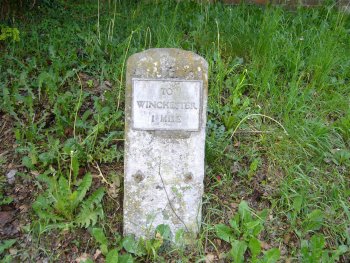
Stockbridge Road Milestone © Barrie Brinkman
This Milestone is on the Stockbridge Road. This was the Winchester and Stockbridge Turnpike road to Stockbridge. The milestone marking is still visible and it is positioned near St Matthews Church on the left leaving the City of Winchester.
Godson was paid 9 shillings in 1751 to measure and a produce map around Winchester. The one mile to Weeke was measured from the West Gate via modern St Pauls Hill and Upper High Street for the milestone.
The City Boundary has evolved over the years. The first three boundaries were within the Weeke Milestone. The first was set when Godson drew his 1750 map, which shows the city boundary at the City Ditch in Fulflood.
In 1832 the boundary was redrawn by Lieut Robert Dawson RE on the Ordance Survey 2 inch map. This boundary ran from Jolly Farmer Public House to the Roebuck Public House. There is BW on front wall of the Roebuck PH. It then goes across to Romsey Road at former central entrance to the prison near where the Turnpike Gate was situated.
The boundary then moved further out close to the present junction of the Stockbridge Road and Chilbolton Avenue in 1901 (?).
The third move of the boundary moved beyond the milestone to close to the Stockbridge Road and Harestock Road junction in 1932. This is still the City boundary.
All travellers before 1900 commented on huge flocks of sheep and the bareness of downs of the Itchen valley. Jane Austen wrote to a nephew in 1816 the ill-natured Aspersion on poor old wintons want of a tree within some miles of the city. This gives a good impression of what the Weeke area looked like before its development.
Romsey Road Milestone
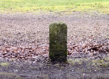
Romsey Road Milestone © Barrie Brinkman
This is the milestone on the Romsey Road and refers to the Westgate of Winchester at a mile away and 10miles to the Corn Exchange at Romsey. The Milestone is on A3090 (formerly A31) near Sleepers Hill.
Thomas Hardy makes several references to Winchester and the mile marker on the Romsey Road. In Tess of the DUbervilles Hardy refers to Winchester as Wintoncester . Later he describes the first milestone, standing whitely on the green margin of the grass backed by the down which was here open to the road. In Aug 1893 Hardy took Mrs Florence Henniker to see the cathedral for evensong and then they walked the mile along Romsey road. The view included Cathedral, College, prison, St Cross hospice and St Catherines Hill and spires of St Thomas church (1856-7). He omits the hospital and training College (now King Alfreds College) 1862.
Behind the milestone were open downs that were part of Teg Down Farm. Keats made a walk in this area on Sunday 19th Sept 1819 in Itchen valley. He wrote ode in Autumn.
At St Cross, Priors Barton from medieval times vast flocks on Downs were farmed Lambs at Littleton, tegs (immature sheep') near the milestone and older sheep beyond St Catherines Hill. Keats included, in his ode, the line:-
Then full grown Lambs loud bleat from hilly bourne.
Release 2.0 last update 23/04/19