WEEKE HISTORY
Parish Boundary
During the eight century the procession about the fields to ask for God’s protection on crops, beasts and people had become established in England. Before long it became associated with the ancient custom of fixing territorial boundaries by ceremonially walking them annually. This took place on the Monday, Tuesday, and Wednesday before Ascension Day and is called Rogantide. Crop blessing and boundary processing were thereafter performed during the same ceremony. This continued until the Reformation when the blessing of crops was considered ‘popish’ or ‘superstitious’. ‘Beating the bounds’ therefore became the more important element and continued (Lloyd, 2001-2).
Parish clergy have continued to play an important role in the perambulations and effectively ‘legitimised’ the activity. At each boundary in a country parish would be stream, boulder or other natural feature. At this feature the clergy would recite a suitable passage from scripture.
It was essential to know where the boundaries to the parish were located. In a period when there were no maps, printed records, or general literacy older members of the community would be very important in maintaining an oral tradition. This practice started to decline with the Enclosure Acts to define enclosure arrangements in many parishes. Another activity which encouraged the decline was the publication of Ordnance Survey maps which began in 1801. Weeke did not have an Enclosure Act because most of the land was owned by the Church in the form of the Dean and Chapter of Winchester Cathedral who could reorganise the leased land directly.
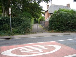
The boundary of the historic Weeke parish can be followed by starting at the lowest point of the parish which is about 200 feet above sea level at the intersection of modern Andover Road, Stockbridge Road, City Road and the Railway Station Approach. The line of the Parish actually passes part way along City Road and behind Eagle Court, the conversion of the earlier Eagle Public House. It is thought that the boundary at this point does not follow the old Roman Road to Cirencester (the modern Andover Road) because the original Mother Church for Weeke (St Marys in the Valley) was located in the area of Eagle Court which had been an earlier Roman Cemetery.
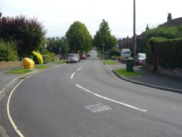
The boundary runs parallel to the Andover road and then crosses the modern Worthy Road before joining the Andover Road. The line does not exactly follow the road because when the London and South West Railway line was built in the late 1830s the road had to be realigned for the bridge over the railway on the Andover Road. The line then follows the road past the Jolly Farmer Public House. The original Public House was created from a private house in 1835 but the present building was rebuilt and positioned on the site in 1904. Next to the Public House is an area that was called Gallows Close (HRO 21M65/F7/261/1). This was used for a long period as the location for hangings for prisoners from Winchester. They were marched out from the gaol in Jewry Street to be hanged close to where the modern Public House is located. This continued until 1819 when a large crowd attended a burning. The Authorities decided that all future burnings would take place in the precincts of the Jewry Street gaol (Carpenter Turner, 1992 p125). Public hangings actually continued being transferred to the new County Prison on Romsey Road. The last public hanging was in 1867 for the murderer of the infamous Fanny Adams (URL 17).
Heafod Stoccum 2007 © Barrie Brinkman
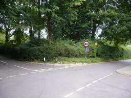
The boundary then follows the Andover Road climbing all the time until an important junction is reached just before you reach the modern Henry Beaufort Comprehensive School at a height of 250 feet above sea level. Four parish boundaries meet at this point. Weeke boundary meets Littleton boundary which is further away from Winchester. On the other side of the Andover Road is the parish of St Bartholomew Hyde that meets Headbourne Worthy parish. This point is recorded in a Saxon Charter for Headbourne Worthy as HEAFOD STOCCUM. There is some doubt about the meaning of this name. It could mean poles marking the limits of the headlands of the plough lands, but another suggestion is it refers to a place where the heads of criminals were impaled after execution. No matter which meaning is assumed this was obviously an important point locally. It is possible the local name Harestock is derived from this name.
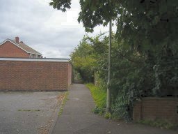
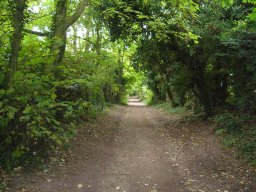
View from Fromond Rd back along the footpath
2007 © Barrie Brinkman
Turning away to the left of Andover Road the boundary between Weeke and Littleton parish follows a zigzag path following field boundaries between the two parishes, eventually reaching the modern Stockbridge Road.
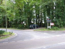
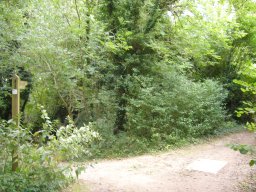
Wyke Mark 2007 © Barrie Brinkman
This point is called Wyke Mark and is the termination of the Weeke and Littleton boundary. The Littleton boundary follows the Stockbridge Road away from Winchester. The name Wyke Mark was given to a house opening on Dean Lane early in the 1900s, this later became an old peoples home and in recent times was demolished for retirement flats still called Wyke Mark. The junction consists of the modern Stockbridge Road, Harestock Lane and Salters Lane. In addition on early Ordnance Survey maps Littleton Road which leads into Littleton actually met Stockbridge Road at the junction. It has Stockbridge Road at the junction. It has more recently been realigned to meet the Stockbridge Road further away from Winchester.
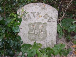
Winchester Boundary Stone
2007 © Barrie Brinkman
The modern name on maps for Wyke Mark is ‘Harestock Corner’ and there is a boundary stone that indicates the boundary to Winchester Borough and was probably positioned early in 1930s.
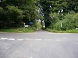
Salters Lane JCT with Dean Lane
2007 © Barrie Brinkman
The boundary crosses the Stockbridge Road and follows a path that divides Weeke from Sparsholt parish. This is a field boundary that follows the modern Salters Lane. This then reaches and crosses the modern Dean Lane.
Lanham Lane Bridleway 2007 © Barrie Brinkman
The route follows a path that has become the modern Lanham Lane. The Lane follows the Weeke and Sparsholt boundary and passes the top end of the modern Teg Down Meads. The modern tarmac road then becomes a bridleway that probably looks like the path that existed for many centuries along the parish boundary.
Lanham Lane JCT with Clarendon Way
2007 © Barrie Brinkman
The path continues to separate Weeke and Sparsholt parishes and slowly rises until the highest point in the parish is reached at a height of approximately 500 feet above sea level. The boundary of the parish leaves Lanham lane, which continues to join Sarum Road further out from Winchester.
Clarendon Way JCT with Sarum Rd
2007 © Barrie Brinkman
The boundary turns a very sharp left to start the return back to Winchester. Initially it follows a bridleway dividing Weeke parish from Hursley parish. This path passes the radio masts on Sarum Farm and to the right is the Pinsent camping ground used by Scouts and Guides. The path opens out to a tarmac road which is called Clarendon Way and is the part of the Clarendon Way path that runs from Winchester to Salisbury. This road meets Sarum Road which is part of the original Roman Road to Salisbury.
The boundary crosses the Sarum Road and follows Kilham Lane until it meets the modern Romsey Road. The boundary turns back towards Winchester with St Faiths parish to the right of the road. The boundary follows the road until it meets Sarum Road on the way into Winchester.
Greenhill Rd 2007 © Barrie Brinkman
The parish boundary then heads away from Romsey Road along a line close to the modern Greenhill Road and then runs parallel to Romsey Road. This seems surprising since it might be expected that Weeke parish boundary would follow the line of Sarum Road into Westgate, at the city wall boundary. It is possible that part of the land between Romsey Road and the actual boundary (now used by West Down, Hilliers Nursery, Winchester Prison and Hants Police Headquarters) may have been part of the defunct St James parish and then became part of St Faiths parish.
The boundary finally reaches the modern Oram’s Arbour (named after Alexander Oram who built a house in the seventeenth century in this area). The boundary then passes to the south of St Pauls, the site of the New Winchester Union Workhouse and crosses the railway. The line runs across to the modern Sussex Street, with St Thomas parish forming the boundary to Weeke parish. The line finally then runs parallel to Sussex Street and crosses City Road to return to the start of the boundary.
The parish boundary has obviously often been lost in some places within modern properties. It is possible to follow a modern line that closely follows the boundary by starting at the bottom of Andover Road where it starts by City Road. Andover Road can be followed out of town towards Three Maids Hill.
The junction of the four parishes is marked by a footpath that can be followed. This path divides the modern Weeke Manor Estate from the later Harestock Estate. The path zigzags following the original field boundaries. In 1960s, when the Weeke Manor Estate was built a boundary change was made with Littleton Parish. A major part of a field called Rewlands in Littleton became part of the new City Boundary and so was absorbed into Weeke. The line of this field can be seen in the large trees in Rowlings and Taplings roads, part of the modern Weeke Manor Estate.
The path follows the edge of Weeke Manor Estate coming out at Harestock Corner where it meets the Stockbridge Road. Salters Lane then Lanham Lane can be followed out to the bridleway. The bridleway eventually reaches the highest point in the parish. The path can then be followed to Sarum Road with the Royal Winchester Golf Course to the right. Sarum Road can be crossed and Kilham Lane followed to Romsey Road.
The Romsey Road can then be followed back towards Winchester until the junction with Sarum Road is reached. The Sarum Road can be followed, away from Winchester, for a few yards to the start of Greenhill Road. Greenhill Road can be followed through the sharp turn to the right and all the way along the road until Cheriton Road is reached. By turning right into West End Terrace after a few yards the North View footpath can be followed. North View opens out to Oram’s Arbour and the wall of St Pauls can be followed into Clifton Road. The boundary can be followed by turning left and immediately right over the railway bridge. By turning left and right into Newburgh Street, Sussex Street can be reached and then back to the City Road junction. This perambulation is approximately 6 miles and will take about 21/2 to 3 hours.
Release 1.0 last update 11/12/07